Helping Vulnerable Communities Survive Disasters
Sparked by humanitarian organizations like the American Red Cross, backed by companies like JP Morgan Chase & Co., and enhanced with data sharing from Facebook, vulnerable communities now have a better chance at surviving disasters thanks to a program called Missing Maps.
A disaster can devastate any community, but historically, the damage is considerably more widespread in the world’s poorest and most vulnerable communities. For example, on October 4, 2016, when Hurricane Matthew made landfall on the southern peninsula of Haiti, over 3,200 homes were destroyed and more than 15,000 people were displaced. In Haiti alone, over 1,000 people died because of this storm.
Many times, if a disaster occurs in a vulnerable, unmapped location, first responders lack the information necessary to make valuable decisions regarding life-saving relief efforts. Missing Maps is a collaborative project that literally puts these vulnerable communities on the map. This way, humanitarian organizations can better meet the needs of the communities and people they are trying to help.
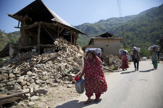
Digital volunteers working with Missing Maps have helped map the homes of 8 million people worldwide. Data from the program has already begun to enhance disaster response efforts — examples include Typhoon Haiyan that struck the Philippines in 2013, and the Nepal earthquake, in 2015.
JP Morgan Chase and its employees are supporting Missing Maps by participating in “mapathons,” where volunteers create digital maps for the world’s poorest and most vulnerable communities. Kathy W., a Business Operations Executive at JP Morgan Chase, commented on the effectiveness of the program, stating, “The work we’re doing really helps to build more resilient communities and helps save lives.” Chase employees have held 22 official “mapathon” sessions and have helped put vulnerable communities in South Africa, Vietnam, Colombia and Peru on the map.
Recently, Facebook joined the efforts and began sharing its population density data with Missing Maps in hopes of putting 200 million more people on the map. This will help the Red Cross and other organizations on the forefront of this project to reach their mapping goals.
Earlier this year, Facebook began applying techniques from computer vision satellite imagery to generate high-resolution population maps that indicate how and where people are aggregated in communities throughout the world. Originally intended to aid in developing geographically specific communications technologies, Facebook decided to publicly share this data in hopes of helping first responders and humanitarian organizations increase efficiency with disaster planning and disaster response.
As part of its work with Missing Maps, the American Red Cross has already implemented data from Facebook, mapping more than two million people in Malawi alone. The humanitarian organization plans to continue to use this data to map vulnerable communities in other disaster-prone areas, like Haiti.
– Ashley Henyan
Photo: Flickr
