FloodWatch India 2.0: Fighting Against Floods in India
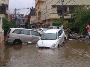 India’s rich diversity and vast landscape have long been admired. However, every monsoon season leaves behind a trail of devastation, damaged roads, displaced communities, lost lives and billions of rupees in property damage. Out of the country’s 329 million hectares of geographical area, 40 million hectares are flood-prone, particularly across the Indo-Gangetic-Brahmaputra plains. In the past decade alone, India has suffered damages worth approximately $540 million.
To address these recurring challenges, the National Disaster Management Authority (NDMA) has turned to technology. The government’s tech-driven fight against floods in India using apps, mapping and smarter alerts represents a shift toward proactive preparedness and citizen-focused safety measures.
FloodWatch India 2.0: Real-Time Alerts at Scale
In the wake of the frequent floods, the government of India launched a revolutionary real-time flood alert app, FloodWatch India 2.0. The key features of the app are as follows:
- Real-Time Forecasting
- The app gives live updates from 592 monitoring stations, a big jump from the earlier 200.
- These stations track rainfall, river levels and water flow, which helps generate accurate flood forecasts.
- Reservoir Tracking
- It monitors the storage levels of 150 major reservoirs across India.
- Since these reservoirs are critical for drinking water, irrigation and power, this feature helps people anticipate risks of overflow and downstream flooding.
- Advanced Flood Information
- One of the standout features is its ability to predict the likely extent of submergence in flood-prone areas.
- This gives citizens time to plan evacuations or take protective measures.
- Comprehensive Coverage
- The forecasts extend to regions downstream of the 150 nationally monitored reservoirs.
- This ensures wider protection for vulnerable communities.
- Technology & Working
- Uses satellite data to analyse rainfall patterns, river conditions and other flood indicators.
- Employs advanced mathematical models that combine real-time data, weather forecasts and historical trends.
GIS and Remote Sensing in Flood Risk Assessment
Geographic Information System (GIS) and remote sensing are widely used for identifying flood risk and vulnerability, as they allow the integration of digital elevation models, soil maps and historical rainfall data into regional development planning. These tools support pre-flood assessments, detection of prior floods and land use and land cover classification.
Flood risk maps are often created using compound hazard and vulnerability indices together with methods like the Analytical Hierarchy Process (AHP), which highlight high-risk zones such as in the Gangetic basin and flood-prone areas of Assam. Such approaches show that remote sensing and GIS are effective in minimizing runoff, supporting rainwater harvesting and preparing communities for potential disasters.
Advanced techniques are also being applied to improve accuracy and coverage. Remote sensing has been combined with clustering algorithms and multi-temporal satellite data to identify flood hotspots across south Asia, while integrated systems using machine learning with AHP generate detailed hazard maps that reflect varying vulnerability levels.
In urban areas, GIS and field surveys are applied to address drainage challenges, such as those along the Yamuna in Delhi. Other methods include using drainage density, slope and land use data to estimate flood risk or analysing time-series satellite images in data-deficient regions. Some approaches also incorporate community perception and mitigation measures into risk assessment, offering a more holistic understanding of hazards and ensuring that flood management strategies are both data-driven and socially responsive.
Floods, Food Security and Poverty in India
Floods are not only a humanitarian crisis but also a threat to economic and food security. Between 1900 and 2020, the country faced more than 300 floods that displaced 30 million people annually and caused more than 1,500 deaths each year. The 2013 Uttarakhand floods alone claimed more than 6,000 lives and caused losses exceeding $3.8 billion.
Such events disrupt food production, storage, access and utilization, directly undermining food security. This vulnerability feeds into poverty cycles, as families lose both food and income when crops, livestock and livelihoods are destroyed. Rural areas, with fragile housing and limited infrastructure, face prolonged recovery, while cities like Delhi and Chennai struggle with dense populations and inadequate drainage.
Weak early warning systems worsen the toll. Addressing these challenges requires resilient infrastructure—stronger drainage networks, flood barriers and durable housing—that can reduce damage and speed recovery. By breaking the cycle of flooding, hunger and poverty, India can strengthen long-term resilience.
A Technology-Backed Future
India’s reliance on technology, for example, FloodWatch India 2.0, demonstrates a clear evolution in disaster management. The integration of tech-driven fight against floods highlights not just preparedness but also resilience. As climate instability intensifies extreme weather, these innovations will play a critical role in safeguarding communities, reducing economic losses and ensuring a more secure future.
– Chhahat Kaur Gandhi
Chhahat is in New Delhi, India and focuses on Business and New Markets for The Borgen Project.
Photo: Wikimedia Commons
