Flood Warning System Saves Lives in the Philippines
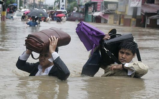
The Philippines is the most exposed large country in the world to tropical cyclones. The storms have shaped settlement patterns in the northern islands for centuries and have killed thousands of people, wreaking havoc on rural communities already mired in poverty. A simple yet effective new flood warning system is already saving lives.
In November 2012, the United States Agency for International Development (USAID), in partnership with the Philippine Partnership for Development of Human Resources in Rural Areas, launched the Agusan Marsh Climate Change Adaptation Project to help 61 villages, including La Flora, increase their resiliency to climate change.
The Agusan Marsh Wildlife Sanctuary is a protected area in the Philippines, roughly the size of metro Manila and home to approximately 120,000 people, 80 percent of which belong to the indigenous Manobo tribe. The tribe is dependent on the regions numerous large lakes, forests and rice paddies, which are all essential to the tribe’s way of life. The region’s features are necessary for fishing, farming and wood gathering, however, they also make the land extremely susceptible to flooding. Although its inhabitants are fully aware of the dangers, the rains have increased over the years and the storms that bring them have become more frequent.
Villagers settled along the marshes in stilted homes and floating communities are acutely aware of the flooding that occurs. However, as climate change is fiercely debated but not felt in the largest carbon producers of the world, the problem hits very close to home in the Philippines, with storms intensifying and recurrent flooding destroying lives.
According to USAID, the Agusan Marsh Climate Change Adaptation Project, in addition to educating villagers about adapting farming techniques to environmental changes, has also developed hazard maps using geographic information systems and flood early warning systems. Outreach campaigns taught families how to prepare for and respond to natural disasters.
In La Flora, USAID introduced a simple flood warning system consisting of color codes painted on houses designed to be easily understood by the whole population, spreading the message about flood severity and evacuation.
The system works using colors. The colors act as watermarks: yellow suggests monitoring weather, orange indicates pre-evacuation measures and red represents full evacuation.
In 2014, the warning system proved valuable when a tropical depression storm swept through the area devastating half a million people. In La Flora, residents adhered to the warning system and although water reached 24 feet almost submerging even the tallest buildings, the entire village of 1,120 survived.
As climate change intensifies and the flood waters rise, with the help of USAID and its partners, those affected most—the indigenous cultures of the low lying islands and marshes—will be more prepared and adaptive to the disasters that will inevitably come.
– Jason Zimmerman
Sources: USAID, United Nations Development Programme,
Photo: Telegraph